
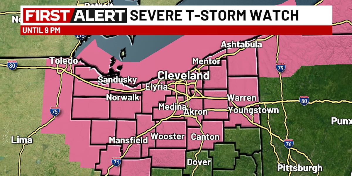
Northeast Ohio is currently under a multi-layered meteorological threat, prompting urgent operational adjustments across industrial and logistical sectors. The National Weather Service has issued Severe Thunderstorm Warnings and Tornado Warnings for core counties including Cuyahoga, Geauga, and Lake, focusing on infrastructure resilience against projected 70 mph wind gusts and significant hail.
Strategic decision-makers in regional transport and utility sectors are navigating a high-risk window extending through the late evening. Storm cells are moving east at approximately 45 mph, compressing the timeline for emergency response and facility securing, particularly for outdoor operations and logistics hubs.
Infrastructure Vulnerability and Utility Resilience
The projected 70 mph winds pose a direct threat to the regional power grid’s distribution integrity, especially in heavily wooded areas within Geauga and Trumbull counties. Wind velocities of this magnitude can exceed the structural thresholds of aging utility poles and overhead lines, increasing the likelihood of localized cascading failures and widespread outages.
Utility providers are mobilizing line crews and prioritizing the restoration of critical infrastructure. The timing of these storms during peak evening hours complicates repair logistics due to hazardous road conditions and reduced visibility.
In addition to wind, penny to ping-pong ball-sized hail presents a significant risk for commercial asset management. Facilities with large rooftop footprints or substantial vehicle inventories face a high probability of structural and cosmetic damage.
Logistical Disruptions Along I-80 and I-90 Corridors
The storm’s trajectory directly intersects critical freight arteries, including the Ohio Turnpike (I-80) and the I-90 lakeshore route. High-profile vehicles are particularly vulnerable to 70 mph gusts, which can cause lane departures, jackknifing, and prolonged closures of vital supply chain links.
Freight operators and fleet managers must balance delay costs against the risk of asset loss as the storm line moves eastward. The rapid storm progression necessitates a shift toward temporary staging and shelter-in-place protocols for long-haul drivers.
Aviation operations at Cleveland Hopkins and Akron-Canton are also impacted, with severe thunderstorm and tornado threats leading to the suspension of ground operations. These delays create ripple effects across national air traffic networks, disrupting cargo and passenger transit.
Hydrological Risk and Urban Drainage Systems
As the immediate severe weather threat evolves, the secondary risk of flooding emerges as a concern for municipal authorities. Rainfall totals are expected to exceed 1.5 to 2 inches in concentrated areas, testing the capacity of urban drainage systems in Cuyahoga and Summit counties.
The transition from a wind-driven event to a hydrological one indicates that the economic impact may extend into the following business day. Saturated soil conditions and rapid runoff increase the likelihood of basement flooding and road washouts, particularly in low-lying areas near the lakeshore.
Institutional stakeholders, including the 3News Weather Team and regional emergency management agencies, have designated this a “19 First Alert Day,” triggering heightened public awareness and resource allocation to mitigate human and financial costs from isolated tornadoes and damaging straight-line winds.
Strategic Implications of the Two-Wave Storm Structure
The forecast indicates a distinct two-wave storm structure, complicating recovery and assessment. The first cluster, moving through early evening, precedes a second wave associated with a cold front arriving later tonight. This staggered arrival requires crews to remain ready for a second period of volatility.
The second wave, expected to intensify around 8-9 PM near the lakeshore, ensures the threat remains active through midnight, impacting late-shift industrial operations. For 24-hour manufacturers and distribution centers, this prolonged threat window necessitates strategic evaluation of shift safety and active shelter protocols for potential isolated tornadoes.
Economic and Insurance Sector Exposure
The insurance sector anticipates a concentrated period of claim activity following reports of ping-pong ball-sized hail and 70 mph winds. Property and casualty insurers are likely to see a surge in filings for roof damage, broken windows, and vehicle impacts across the fifteen counties under the Severe Thunderstorm Watch.
The geographic breadth of the watch, from Erie to Trumbull and south to Holmes and Wayne, distributes financial exposure across urban centers and agricultural regions. Early-season plantings may be susceptible to heavy rain and hail impact.
The potential for flooding on April 1st introduces a different risk class, often outside standard commercial policies. Businesses without specific flood endorsements may face financial consequences from the predicted 2-inch rainfall totals.
Institutional Communication and Public Safety Protocols
The National Weather Service and local media are critical in disseminating actionable data. Specific warnings for Trumbull, Portage, and Geauga counties enable targeted responses, reducing “warning fatigue.” The 5:58 PM report tracking the storm line from Geneva-On-The-Lake to Hudson exemplifies the high resolution of modern meteorological monitoring, allowing for granular facility closure and resource deployment decisions.
As the severe threat diminishes overnight, focus shifts to lingering showers and the rainy forecast for the following day, marking the end of acute risk and the start of chronic operational challenges from a saturated environment.
Regional Connectivity and Cascading Effects
Northeast Ohio’s interconnected economy means disruptions in Cuyahoga County impact surrounding areas like Medina, Lorain, and Portage. Supply chains relying on just-in-time delivery are particularly sensitive to storm-induced road closures and power outages.
Institutional memory of past severe weather suggests that recovery time for the power grid and transportation networks will be key economic impact metrics. FirstEnergy and other local utilities’ restoration speed will determine lost productivity in the manufacturing sector.
This event serves as a stress test for the region’s emergency management framework. Coordination between the National Weather Service, local media, and municipal emergency services is the primary defense against unpredictable severe thunderstorms and isolated tornadoes.
Long-Term Structural Considerations
The frequency of “First Alert” days prompts discussion on structural hardening of regional infrastructure. As 70 mph winds and heavy rainfall become recurring challenges, the cost-benefit for undergrounding utilities and enhancing urban drainage grows increasingly relevant for local governments.
The immediate priority is workforce safety and asset protection as the second storm wave approaches. The transition into April 1st will likely be defined by the aftermath and management of resulting hydrological risks.
Stakeholders are advised to remain vigilant until the National Weather Service officially cancels all watches and warnings. Resilience demonstrated during this event will provide critical data for future risk modeling and emergency preparedness in the Northeast Ohio corridor.

Photo by Jonas_Fehre on Pixabay.