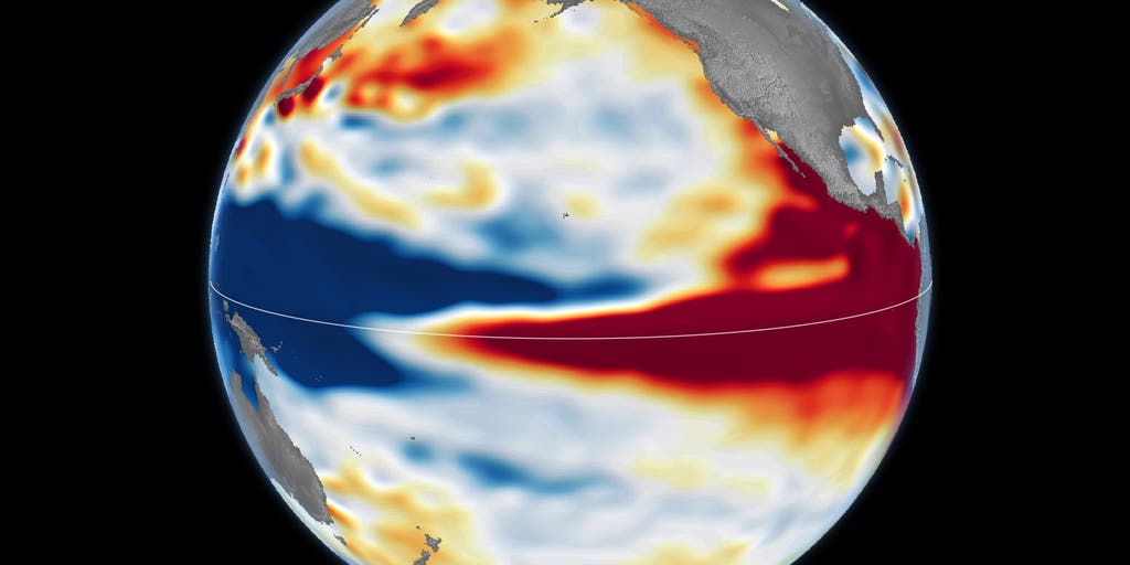
Atmospheric and oceanic metrics indicate an escalating warm phase in the central and eastern tropical Pacific, with observational models assigning an 83 percent probability that the current cycle will match or exceed historically recorded maximums. As sea surface temperature (SST) anomalies expand eastward, this macro-scale phenomenon—recurring cyclically every two to seven years—is restructuring global teleconnections, shifting the mid-latitude jet stream, and recalibrating winter seasonal baselines across the Northern Hemisphere.
Equatorial Thermodynamics and Coupled Atmospheric Dynamics
The progression of a high-intensity El Niño is governed by the coupled ocean-atmosphere Bjerknes feedback loop. Under neutral equatorial conditions, persistent easterly trade winds sustain an east-to-west sea surface height gradient, pooling warm water in the western Pacific warm pool while driving upwelling along the South American coast. When trade winds weaken or collapse into westerly wind bursts, this baroclinic equilibrium destabilizes, discharging accumulated Kelvin waves that transfer subsurface thermal energy toward the central and eastern Pacific basin.
This eastward redistribution of warm equatorial waters shifts convective towers and latent heat release away from the western Pacific. The relocated convective core alters tropospheric thermal gradients and alters Hadley circulation cells. Satellite radar altimetry from NASA indicates that the spatial extent and thermocline displacement of the current event align structurally with the extreme benchmark profiles of the 1997–98 and 2015–16 cycles, while retaining distinct longitudinal variations in core sea surface temperature anomalies.
Jet Stream Bifurcation and Continental Precipitation Regimes
The primary mechanism translating tropical Pacific heat anomalies to North American meteorological patterns is the Pacific-North American (PNA) teleconnection pattern. During an intense El Niño phase, the subtropical jet stream intensifies, elongates eastward, and shifts equatorward across North America. This repositioned upper-level wind field serves as a direct conduit for persistent, moisture-laden Pacific storm tracks across the southern tier of the continental landmass.
Consequently, continental climate signals bifurcate. The southern United States and northern Mexico encounter anomalously high precipitation frequencies, while the northern tier, Pacific Northwest, and Ohio Valley experience diminished storm activity, elevated 500-hPa geopotential heights, and above-average winter temperatures. An evaluation of January-through-March snowfall archives spanning 1959 to 2026 illustrates the non-linear relationship between precipitation volume and frozen surface accumulation: surplus atmospheric moisture along the southern storm corridor frequently interacts with above-freezing boundary layer temperatures, resulting in elevated rainfall totals rather than persistent snowpack.
Historical Extreme Benchmarks and Global Impact Precedents
Comparative analyses of the 1997–98 and 2015–16 analog events demonstrate that Super El Niño configurations induce severe, asynchronous climatic anomalies worldwide:
- Western Pacific and Southeast Asia: Suppressed convective activity drives prolonged drought, precipitating extensive wildfire complexes across Indonesia and neighboring equatorial corridors.
- Southern Africa and Northern South America: Subsidence anomalies generate acute moisture deficits, historically driving widespread crop failure across southern Africa and moisture starvation throughout the Amazon basin.
- Eastern Pacific Coastal Zones: Subtropical moisture plumes deliver intense atmospheric river events, producing catastrophic runoff, debris flows, and coastal infrastructure erosion across Southern California, Peru, and Ecuador.
Sectoral Exposure: Municipal, Agricultural, and Energy Systems
Because long-range seasonal outcomes depend on the exact longitudinal axis of maximum SST anomalies, operational planning cannot rely on static historical averages. The interplay between heightened precipitation and thermal thresholds introduces systemic exposure across key economic sectors:
Civil Infrastructure: Municipalities along the southern storm corridor face heightened capital and emergency expenditures related to stormwater conveyance saturation, levee stress, and slope stability. Conversely, northern jurisdictions must navigate compressed, volatile operating windows for snow removal operations and road treatment inventories.
Agricultural Asset Management: Hydrologic swings disrupt standard agronomic cycles. Severe drought conditions in Southeast Asia and Southern Africa constrain commodity supply chains, while persistent saturation across the southern United States complicates field access, delays seasonal planting, and increases fungal pathogen risk.
Energy Grid Operations: Regional heating degree days (HDD) drop significantly across northern population centers under persistent mild regimes, reducing winter natural gas and electricity peak demand. Concurrently, heightened convective storm frequency across the southern tier increases physical asset exposure and transmission interruption probabilities.
With predictive indicators verifying top-tier event strength, municipal, agricultural, and energy organizations must transition from broad seasonal climatology to real-time satellite radar and teleconnection tracking to mitigate compound weather risks.