
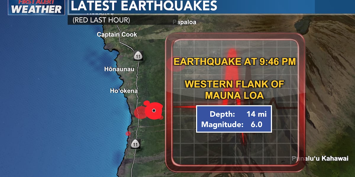
Magnitude 6.0 Earthquake Strikes Hawaii Island, No Tsunami Expected
A magnitude 6.0 earthquake struck Hawaii Island at 9:46 p.m. local time, with its epicenter approximately seven miles east-southeast of Honaunau in the South Kona area. The seismic event’s origin was located about 3.7 miles east-southeast of Honaunau-Napoopoo, on the western flank of the Mauna Loa volcano, according to the U.S. Geological Survey (USGS).
The Pacific Tsunami Warning Center (PTWC) confirmed no tsunami was generated, mitigating immediate coastal threats. Despite the lack of a tsunami alert, strong shaking was reported across the Hawaiian archipelago, including as far as Omao on Kauai. Residents on Oahu, in areas like Kailua, Ewa Beach, and Kapolei, also experienced significant tremors, indicating the widespread impact of the seismic activity.
Further reports of intense shaking came from Makawao and Wailuku on Maui, underscoring the event’s broad reach. While the USGS initially reported a magnitude of 6.0, some sources noted a 5.9 magnitude. This minor discrepancy does not alter the core implications of the seismic event.
Geological Context and Mauna Loa’s Activity
The earthquake’s location on Mauna Loa’s western flank is geologically significant, as the volcano is one of the world’s most active shield volcanoes. Such seismic activity is recurrent in Mauna Loa’s environment, often associated with magma movement and volcanic unrest. The epicenter’s proximity to populated western island areas necessitates continuous monitoring by geological institutions.
The USGS and PTWC are the primary bodies responsible for monitoring seismic and tsunami threats in the region. Their rapid assessment and communication protocols are vital for public safety in an area prone to both earthquakes and volcanic eruptions. The swift issuance of a no-tsunami alert demonstrates the effectiveness of their established operational framework.
The recurring seismic events in this region highlight the ongoing tectonic stresses beneath Hawaii Island. Understanding the interplay between these earthquakes and Mauna Loa’s volcanic system remains a key area of scientific research. Data from this magnitude 6.0 event will contribute to refining seismic hazard and volcanic behavior models for the Hawaiian Islands.
Infrastructure Impact and Public Response
While no tsunami occurred, the widespread strong shaking raises concerns about potential infrastructure damage. Buildings, roads, and critical utilities are vulnerable to significant seismic events. Assessing the extent of any damage will be crucial for immediate aftermath evaluation and recovery planning.
The broad geographic distribution of reported shaking indicates that emergency management agencies statewide will be engaged in damage assessment and public inquiry response. Communication channels, such as those used by Hawaii News Now, are critical for disseminating official information and safety advisories.
Public reliance on timely, accurate information during and after such events emphasizes the role of established news organizations and official monitoring bodies. The reports of shaking across multiple islands underscore the need for a coordinated response and information dissemination strategy statewide.
Disaster Preparedness Strategic Implications
This earthquake serves as a critical reminder of Hawaii’s inherent vulnerability to natural disasters, including earthquakes and volcanic eruptions. Strategic disaster preparedness planning must account for the cumulative risk posed by these phenomena.
The operational effectiveness of geological monitoring agencies, like the USGS Hawaiian Volcano Observatory, is paramount. Their ability to detect, analyze, and communicate seismic and volcanic threats directly influences the effectiveness of broader disaster response strategies implemented by state and local authorities.
The economic implications of such events, even without widespread destruction, can be substantial, affecting tourism, local businesses, and insurance costs. Comprehensive understanding of seismic risks and robust preparedness measures are thus essential for public safety and economic resilience.
Media Coverage and Information Dissemination
Reporting by Hawaii News Now and Big Island Video News (BIVN) exemplifies the critical role of local media in disseminating information during unfolding events. Their immediate coverage of the earthquake’s magnitude, location, and the absence of a tsunami alert provided essential situational awareness for residents.
The commitment to ongoing updates highlights the dynamic nature of breaking news coverage, crucial for managing public perception and ensuring accurate information availability to prevent misinformation.
The copyright notice and attribution indicate the proprietary nature of the reporting, while the mention of BIVN suggests a complementary information flow. Verified multi-source reporting strengthens the overall public information landscape.
Institutional Response and Monitoring Protocols
The involvement of the USGS and PTWC signifies the established institutional framework for managing seismic and tsunami risks in the Pacific. These agencies operate sophisticated monitoring networks and employ experts to provide timely alerts and assessments.
The PTWC’s role is critical in a region surrounded by the Pacific Ocean, where tsunamis pose a significant threat. Their ability to quickly rule out a tsunami based on seismic data and oceanographic models demonstrates advanced technology and protocols.
The USGS, through its Hawaiian Volcano Observatory, maintains constant surveillance of Mauna Loa and other Hawaiian volcanoes. This continuous monitoring is essential for detecting any changes in volcanic activity linked to seismic events, providing early warnings for potential eruptions.
Broader Implications for Seismic Hazard Assessment
The magnitude 6.0 earthquake on Mauna Loa’s flank contributes to scientific understanding of seismic hazards in volcanic regions. Such events provide valuable data for refining seismic hazard maps and probabilistic seismic hazard assessments.
These assessments are crucial for informing building codes, land-use planning, and infrastructure development in seismically active zones. Consistent monitoring and analysis of seismic activity by institutions like the USGS are foundational to these efforts.
The long-term implications extend to the scientific community’s efforts to understand the complex interplay between volcanic processes and tectonic faulting in the Hawaiian hotspot. Each seismic event offers new insights into the subsurface dynamics of this geologically active area.
Economic and Social Resilience in Hawaii
Hawaii’s tourism-dependent economy is particularly sensitive to natural disaster disruptions. While this earthquake did not trigger a tsunami or widespread destruction, the perception of risk can influence travel decisions and economic activity.
The social fabric of island communities is tested during such events, with an emphasis on mutual aid and community support. Community resilience is often a function of preparedness, clear communication, and effective coordination.
Ongoing monitoring and preparedness efforts by state agencies, in collaboration with federal scientific bodies, are vital for maintaining economic stability and social cohesion amid recurring natural hazards.
Future Monitoring and Research Directions
Data from this magnitude 6.0 earthquake will be meticulously analyzed by seismologists to better understand fault mechanisms, stress accumulation, and aftershock potential. This analysis is crucial for refining seismic hazard models specific to the Mauna Loa region.
Further research may focus on correlations between this earthquake and any subtle changes in Mauna Loa’s volcanic activity, such as ground deformation or gas emissions. Such correlations could offer valuable insights into the dynamic relationship between tectonic stress and magmatic systems.
The continuous operation of seismic networks and commitment to scientific research are fundamental to Hawaii’s long-term strategy for managing its unique geological environment and ensuring the safety of its residents and visitors.
Photo by Makalu on Pixabay.