Northeast Ohio Under Severe Storm Watch: Flooding and Wind Damage Imminent
Northeast Ohio is bracing for a significant severe weather event as multiple storm systems are forecast to impact the region. The primary concerns are widespread heavy rainfall, which poses a substantial risk of localized flash flooding, particularly in areas experiencing repeated storm cell passage. This deluge presents immediate operational challenges for municipal infrastructure, including drainage systems, and for emergency services responsible for public safety and water management.
In addition to inundation risks, the most intense storm cells are expected to produce damaging wind gusts. These extreme winds have the potential to cause widespread tree damage, leading to significant power grid disruptions affecting residential and commercial energy consumers. The unpredictable nature of these gusts necessitates proactive preparedness by utility providers and property owners to mitigate damage and ensure service continuity.
Lightning remains a critical safety hazard, with official advisories strongly recommending immediate indoor shelter upon hearing thunder. This directive highlights the immediate personal safety implications for all residents, especially those engaged in outdoor activities. The timing of these storms, predominantly during the afternoon and evening hours, coincides with peak commuting times and public event schedules, amplifying the urgent need for heightened public awareness and vigilance.
Regional Impact and Public Event Safety
The Cleveland Metro area, among other densely populated zones, is particularly susceptible to storm development during periods of high public engagement. Attendees of outdoor festivals, sporting events, and other gatherings are strongly advised to monitor weather updates closely. Rapidly developing heavy downpours can quickly create hazardous driving conditions due to road pooling and severely reduced visibility, impacting traffic flow and increasing the likelihood of accidents.
For individuals attending events at venues such as Huntington Bank Field, the dynamic forecast demands flexibility in travel plans and on-site presence. The potential for brief but intense precipitation necessitates that outdoor venues implement robust contingency plans to manage rapidly changing conditions, ensuring both spectator safety and operational integrity for event organizers.
Severe Thunderstorm Watch Details and Specific Hazards
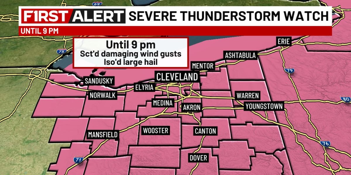
A comprehensive Severe Thunderstorm Watch has been issued for all of Northeast Ohio, currently set to remain in effect until 9 p.m. While a region-wide severe weather outbreak is not currently anticipated, the watch signifies an elevated risk for localized severe thunderstorm development. This official alert from meteorological agencies serves as a critical trigger for preparedness actions across various sectors and government levels.
Key hazards to monitor include strong, gusty winds, torrential rainfall, and the potential for large hail, with stones possibly reaching quarter-size dimensions. These elements pose direct threats to property, infrastructure, and agriculture, requiring businesses and homeowners to secure outdoor items, reinforce vulnerable structures, and take precautions against potential damage. The financial repercussions for the insurance industry and subsequent repair services could be substantial, contingent on the observed severity and extent of damage.
Waning Threat and Subsequent Weather Shifts
The peak of the severe weather threat is projected to subside around sunset, anticipated shortly after 8 p.m. However, scattered showers and isolated thunderstorms are expected to persist through the overnight hours, indicating a prolonged period of unsettled atmospheric conditions. This lingering activity can continue to present localized hazards and impact transportation, particularly for late-night travelers.
Looking ahead to Sunday, a significant cooling trend is forecast, with daytime highs expected to reach only the low 70s Fahrenheit (approximately 21-23°C). This atmospheric shift will be accompanied by the likelihood of scattered, lake-effect driven showers and a persistent gusty breeze. The interaction between the cooler air mass and warmer lake waters raises the potential for waterspout development, a localized but potentially hazardous phenomenon for maritime activities and coastal properties.
Monday is predicted to remain cool and dry, with similar high temperatures in the low 70s Fahrenheit. This period of relative calm offers a brief respite before the next approaching weather system. Temperatures are forecast to rebound into the upper 70s Fahrenheit (approximately 25-27°C) by Wednesday afternoon, setting the stage for a renewed chance of showers and storms on Thursday and Friday. This cyclical pattern of weather systems underscores the dynamic atmospheric conditions influencing the region and the necessity for ongoing monitoring.
Strategic Imperatives for Regional Preparedness and Resilience
The recurring nature of these severe weather events underscores the critical importance of robust, integrated regional preparedness strategies. For local governments, this necessitates the coordination of emergency response protocols, ensuring sufficient resources for flood mitigation efforts, and maintaining transparent communication channels with the public. The cumulative economic impact of repeated disruptions, ranging from minor property damage to significant infrastructure repair costs, highlights the need for long-term investment in resilient infrastructure and advanced weather management systems.
For businesses operating within Northeast Ohio, the persistent threat of severe storms translates directly into operational risks requiring comprehensive contingency planning. This includes securing supply chains, protecting physical assets, and ensuring employee safety. The potential for widespread power outages, in particular, poses a significant threat to operational continuity, emphasizing the need for backup power solutions and robust business continuity plans. The cumulative effect of such events can influence investment decisions and the broader economic climate of the region.
The role of local media in disseminating timely and accurate weather information is paramount during periods of elevated risk. Designations such as a ’19 First Alert Weather Day’ represent a concerted effort by news organizations to prioritize public safety messaging, delivering continuous updates and actionable advice. This illustrates the crucial symbiotic relationship between meteorological forecasting, emergency management agencies, and public communication in effectively mitigating the impact of natural hazards.
Broader Context: Climate Variability and Infrastructure Resilience
While the current forecast details immediate storm events, it also implicitly touches upon broader, ongoing trends in climate variability. The intensity and frequency of severe weather phenomena are subjects of extensive scientific research and public discourse. For regional planners and policymakers, understanding these trends is fundamental for developing long-term strategies that enhance infrastructure resilience against a backdrop of a changing climate.
The repeated exposure to heavy rainfall and high winds necessitates a critical re-evaluation of existing infrastructure standards. Strategic investments in upgraded drainage systems, reinforced building codes, and comprehensive power grid modernization become increasingly vital. These are not merely localized concerns but reflect a growing global imperative to adapt to more extreme weather patterns, influencing capital allocation and public works priorities across diverse jurisdictions.
The escalating economic burden associated with climate-related disasters is a significant factor in national and international policy discussions. For regions like Northeast Ohio, which experience these events with notable regularity, the financial strain on public budgets and private enterprises can be considerable. This underscores the strategic importance of investing in preventative measures and adaptive technologies to minimize future losses and ensure sustained economic stability.
Stakeholder Exposure and Proactive Risk Management
The stakeholders exposed to these weather-related risks are exceptionally diverse, encompassing individual residents, small businesses, large corporations, and essential public utilities. For residents, the immediate concerns revolve around personal safety and property protection. For businesses, the scope extends to operational continuity, supply chain integrity, and the potential for significant financial losses due to damage or operational downtime.
Public utilities face the dual challenge of maintaining essential service delivery amidst hazardous conditions while simultaneously responding to widespread outages. Their operational strategies must effectively balance immediate repair efforts with strategic, long-term investments in grid hardening and overall resilience. Insurance companies, in turn, must meticulously assess and manage aggregate risk exposure across their policyholder base, which can have a substantial impact on their financial performance and future premium structures.
The cyclical nature of these weather events also demonstrably influences consumer behavior and broader market dynamics. For instance, demand for weather-related services and products, such as generators, storm shutters, and specialized flood insurance, typically surges in anticipation of severe forecasts. This creates significant opportunities for specific industries while concurrently highlighting the inherent vulnerability of sectors heavily reliant on stable weather conditions, such as agriculture and outdoor recreation.
Institutional Response and Communication Frameworks: A Coordinated Approach
The effectiveness of institutional responses to severe weather events is fundamentally dependent on well-established communication frameworks and coordinated inter-agency action. Meteorological agencies provide the foundational data and forecasts, while emergency management offices translate this information into actionable plans for local authorities and the public. The role of media outlets, as exemplified by the ’19 First Alert Weather Day’ designation, is critical for amplifying these warnings and providing continuous, real-time situational updates.
This multi-layered communication system is meticulously designed to ensure that all stakeholders receive timely and relevant information, empowering them to make informed decisions. The success of these collective efforts is measured not only by the accuracy of meteorological forecasts but also by the public’s adherence to safety guidelines and the overall efficiency of emergency response operations. Failures within any component of this chain can lead to significant negative consequences, underscoring the continuous need for evaluation and improvement of these institutional processes.
The financial implications for institutions involved in disaster response and recovery are substantial and far-reaching. Government agencies must strategically allocate resources for emergency services, critical infrastructure repair, and potential aid programs for affected communities. Private sector entities, including construction and repair firms, often experience a surge in demand, while others may face considerable losses due to business interruption. This economic ripple effect vividly illustrates the interconnectedness of severe weather events and overall economic stability.
Long-Term Strategic Imperatives for Enhanced Resilience
The recurring nature of severe weather events in Northeast Ohio compels a strategic re-evaluation of long-term resilience planning. This extends beyond immediate storm response protocols to encompass proactive measures designed to fundamentally reduce vulnerability to future events. For urban planners and infrastructure developers, this means systematically integrating climate resilience principles into the design and construction of new projects, as well as the retrofitting of existing assets.
The capital investment required for such enhancements is substantial, necessitating a clear understanding of the return on investment in terms of reduced disaster-related costs and sustained economic activity. Public-private partnerships are likely to play an increasingly crucial role in funding and implementing these vital resilience strategies. Furthermore, the competitive landscape for companies specializing in climate adaptation technologies and services is poised for significant growth, driven by escalating demand from municipalities and corporations actively seeking to mitigate weather-related risks.
Ultimately, the ongoing challenge posed by severe weather events in Northeast Ohio serves as a compelling microcosm of a broader global trend. The imperative to adapt to evolving environmental conditions and build more resilient communities and economies represents a defining strategic challenge of the 21st century. The decisions made today regarding infrastructure development, policy formulation, and investment strategies will critically shape the region’s capacity to withstand, respond to, and recover from future weather-related shocks.