Wisconsin Braces for Critical Severe Weather Event
Wisconsin is preparing for a significant escalation in severe weather threats as an active weather pattern brings multiple rounds of rain and thunderstorms through the week, coupled with persistent above-average temperatures. Showers and storms that concluded Monday night into Tuesday morning moved across the state from northwest to southeast.
Early Monday night’s storms delivered heavy rainfall, leading to localized flooding concerns, particularly in areas already saturated from a wet first quarter of 2026. Riverine communities facing high water levels experienced the most significant hydrological risk.
First Alert Weather Day Issued for Tuesday Evening
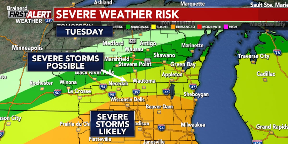
A First Alert Weather Day has been declared for areas around and south of Highway 10, specifically for Tuesday evening. This alert is due to the potential for severe storm development, with all severe weather hazards remaining a possibility. Large hail is identified as the primary concern for this period.
The most critical window for severe weather in Wisconsin is anticipated to be near the Madison area and southeastern Wisconsin. This designation signifies an elevated risk, necessitating heightened public awareness and preparedness from authorities and residents.
Minnesota Experiences Confirmed Tornado and Widespread Severe Storms
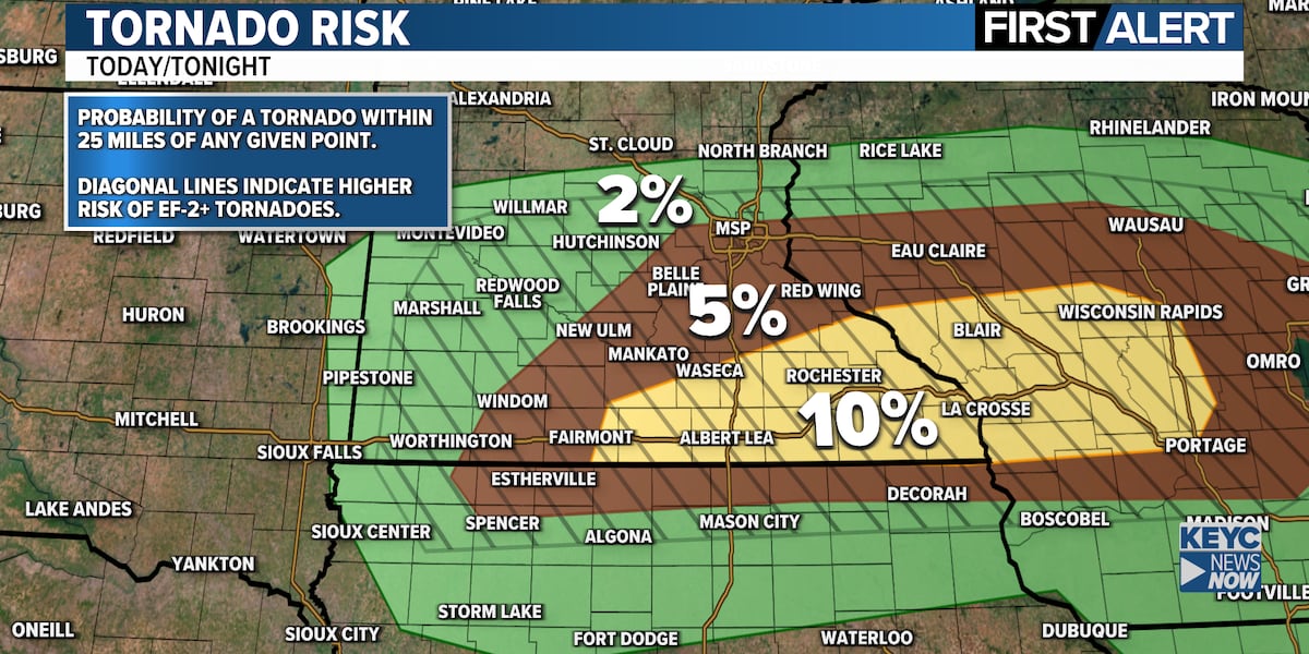
Concurrently, southern Minnesota has already been impacted by severe storms. The National Weather Service confirmed a tornado touchdown in southwestern Blue Earth County on Monday evening. This event, characterized by strong winds that generated significant dust, illustrates the volatile nature of the current weather system.
Over 10 counties in southern Minnesota were under an enhanced tornado watch Monday afternoon, underscoring the broad and severe initial impact of the weather system. While this watch terminated before 10 p.m., the broader atmospheric instability persists.
High Risk Day for Severe Weather on Tuesday
Tuesday is classified as a high-risk day for severe weather, with the likelihood of severe storms significantly increasing from mid-afternoon into the evening. A warm front is forecast to establish across the region, creating an environment highly conducive to storm development.
Regions south of this warm front, encompassing much of southern Minnesota and northern Iowa, are situated within the highest risk zone. The Storm Prediction Center has assigned this area a Level 3 out of 5 risk, indicating a substantial probability of significant severe weather events.
Tornadoes and Large Hail: Primary Threats Identified
Thunderstorm development is expected to commence around or after 3 p.m. Tuesday, potentially along or north of Interstate 90, with a possibility of extending as far north as Highway 14. The initial hours of storm development, from mid-afternoon through early evening, are likely to feature isolated supercells.
These supercell thunderstorms are the formations most prone to producing tornadoes and very large hail, posing the most dangerous and destructive potential impacts. The concentration of these threats in specific geographic zones requires targeted public safety advisories and resource allocation.
Evolving Threats: Damaging Winds and Heavy Rain Anticipated Later
As the evening progresses, storm dynamics may shift, with storms potentially clustering. This clustering could alter the primary threat profile towards damaging wind gusts and heavy rainfall, although the risk for large hail is expected to persist.
This transition in storm behavior has implications for emergency management planning, demanding a flexible response strategy capable of addressing multiple hazard types. The duration and intensity of these later-stage storms will dictate the extent of infrastructure damage and public disruption.
Strategic Imperatives for Emergency Management and Infrastructure Resilience
The recurring nature of severe weather events, including confirmed tornadoes and multiple high-risk days, places substantial operational and financial strain on emergency management agencies. Their response capacity is directly correlated with the frequency and intensity of these meteorological phenomena.
Infrastructure resilience is a critical consideration, with above-average temperatures potentially exacerbating the impact of heavy rainfall and flooding. Utility providers and local governments must assess and reinforce critical infrastructure against the dual threats of extreme weather and heat stress.
Capital Allocation and Risk Mitigation Strategies
The heightened risk of severe weather necessitates a strategic review of capital allocation for infrastructure upgrades and disaster preparedness. Insurance providers face increased claims exposure, potentially leading to adjustments in premiums and underwriting policies for vulnerable regions.
Businesses and agricultural operations in the storm’s path must implement robust risk mitigation strategies, including property securing, communication protocol establishment, and contingency planning for operational disruptions to safeguard assets and revenue.
Effective Media and Public Information Dissemination
The role of meteorological services and local media in disseminating timely and accurate weather information is paramount. Designations like ‘First Alert Weather Days’ and ‘high risk’ days underscore the need for clear, actionable communication to the public.
Public engagement, evidenced by requests for storm photos, highlights the symbiotic relationship between news organizations and the public in documenting severe weather. This crowdsourced data can inform future forecasting models and impact assessments.
Long-Term Weather Patterns and Climate Context
While immediate forecasts are the focus, persistent wet conditions through the first quarter of 2026 hint at broader climatic variability. Understanding these long-term trends is vital for anticipating future weather-related risks.
The expected cooling trend over the weekend offers temporary relief, but underlying atmospheric instability points to a dynamic system requiring continuous monitoring. The interplay between elevated temperatures and storm development warrants ongoing meteorological analysis.
Stakeholder Preparedness and Economic Ramifications
For residents in Wisconsin and affected areas of Minnesota, preparedness is essential. This includes having emergency kits, understanding evacuation routes, and staying informed through official channels. The economic impact can be substantial, affecting agriculture, tourism, and local businesses through direct damage and disruption.
The financial sector, including banks and credit unions, must also consider the potential for increased loan defaults or requests for financial assistance from impacted individuals and businesses. Proactive engagement with affected communities can help mitigate these risks.
Regulatory and Policy Considerations for Enhanced Preparedness
The recurring nature of severe weather events may prompt a review of existing building codes and land-use planning regulations in vulnerable areas. Investing in infrastructure designed to withstand extreme weather is crucial for long-term community resilience.
Government agencies at all levels will continue to assess the effectiveness of their disaster response and recovery frameworks. Lessons learned from significant weather events inform policy adjustments and resource allocation for future preparedness efforts.
Competitive Landscape in Weather Forecasting and Alerting Services
The emphasis on ‘First Alert Weather Days’ and specific threat assessments by entities like the National Weather Service highlights a competitive landscape in meteorological services. Accuracy, timeliness, and clarity of communication are critical differentiators.
Private sector weather companies and media outlets also contribute to this ecosystem, often competing to provide the most detailed and accessible weather information. The public’s reliance on these services underscores their critical function in public safety and decision-making.
Technological Integration in Storm Monitoring and Response
The integration of citizen science and social media, such as viewer-submitted photos and reports, enhances storm event documentation. This crowdsourced data can supplement official observations, providing a more comprehensive understanding of storm impacts.
Advanced radar technology, predictive modeling, and communication platforms are essential tools for meteorological agencies. Continued investment in these technologies is vital for improving forecasting accuracy and the speed and reach of public warnings.
Psychological and Social Impacts of Recurrent Severe Weather
The cumulative effect of frequent severe weather events can lead to increased anxiety and stress within affected communities. Public awareness campaigns focusing on long-term resilience and mental health support are increasingly important alongside immediate threat messaging.
Building community cohesion and fostering mutual aid networks can significantly enhance a region’s capacity to cope with and recover from severe weather impacts. These social structures are as critical as physical infrastructure for overall community well-being.
Environmental Factors Influencing Storm Intensity
Underlying meteorological conditions, such as above-average temperatures and atmospheric instability, are often influenced by broader environmental factors. Understanding these connections is key to long-term risk assessment.
The interaction of warm fronts with cooler air masses, combined with sufficient atmospheric moisture, creates optimal conditions for severe thunderstorms. The precise mechanisms driving the intensity and frequency of such events are subjects of ongoing scientific research and climate modeling.