Meteorological Escalation and Trajectory Dynamics
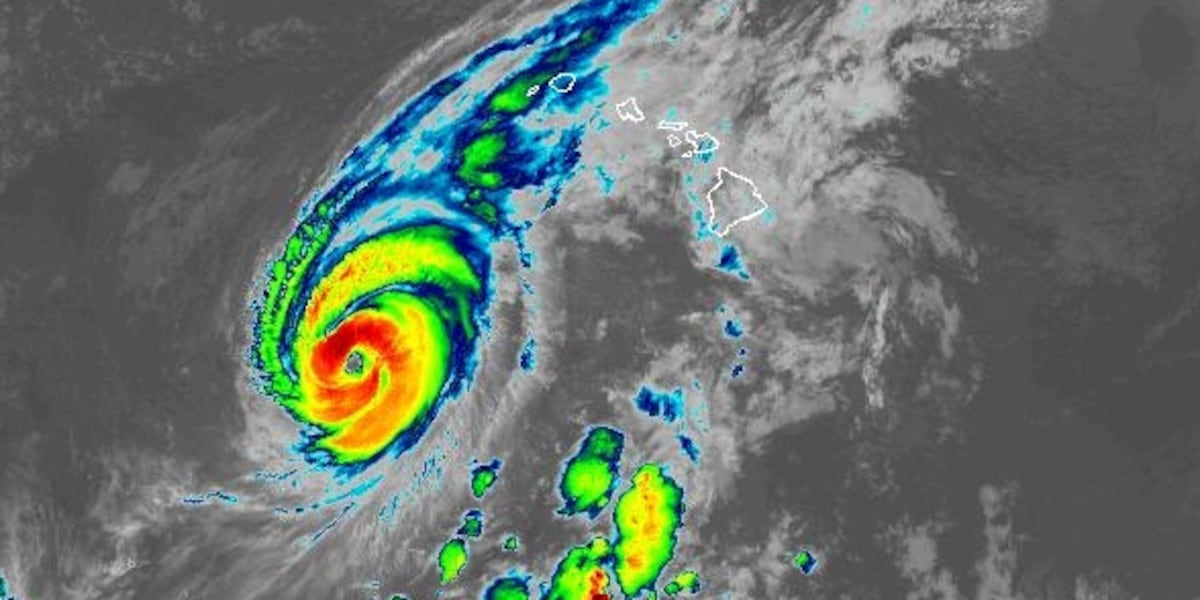
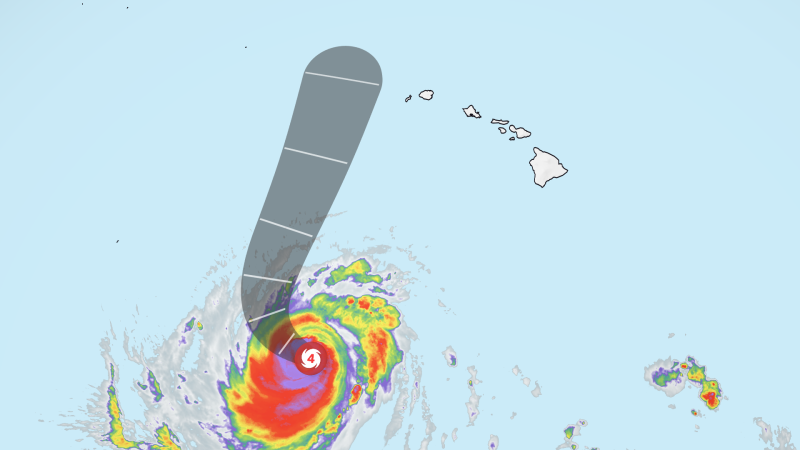
Major Hurricane Lowell has initiated a critical northward redirection, positioning its core on a path that poses severe threats to the western Hawaiian archipelago. The storm, maintaining Category 3 status with sustained winds recorded between 115 and 120 miles per hour, has prompted urgent administrative and civic actions across Kauai County. While the system undergoes the standard structural fluctuations typical of major tropical cyclones, meteorological assessments indicate that it will maintain near Category 2 strength during its closest point of approach.
The current forecasting baseline projects the storm center to track approximately 100 miles west of Niihau and 150 miles west of Kauai between late Monday evening and Tuesday morning. Even with the geographic core remaining offshore, the broader wind field and attendant outer bands present high operational risks for peripheral land masses. The physical buffer provided by this offshore trajectory limits exposure to absolute maximum sustained winds, yet secondary systemic impacts remain an immediate operational hazard.
Regional weather monitoring highlights that this event is the third tropical system to target the Hawaiian islands within a narrow three-week timeframe. This unprecedented sequence is heavily influenced by active El Niño conditions, which continue to supercharge convective potential across the central Pacific basin. The compounding nature of successive storm systems reduces institutional turnaround times and compounds environmental vulnerabilities across fragile island ecosystems.
The Operational Mechanism of Warning Windows
Civil defense authorities have placed Kauai and Niihau under both Hurricane Warnings and Tropical Storm Warnings as the margin for outdoor mitigation narrows. A Hurricane Warning delineates that hurricane-force conditions are imminent within the specified geographical envelope, requiring that defensive measures reach completion before winds exceed critical thresholds. Standard operational doctrine establishes this protocol approximately 36 hours ahead of the anticipated onset of tropical-storm-force winds.
The administrative rationale behind the 36-hour window reflects the physical impossibility of securing infrastructure once ambient winds cross the 39-mile-per-hour baseline. Above this speed, exterior preparation becomes dangerous to personnel, grounding public service operations and halting private logistics. The simultaneous issuance of Tropical Storm Warnings reinforces that gale-force vectors will materialize well ahead of the storm center itself.
The administrative scope of these emergency declarations extends beyond inhabited civilian territory to include the Papahanaumokuakea Marine National Monument, which is also under a Hurricane Warning. Extending high-level warnings to remote maritime conservation zones underscores the massive geographical footprint of Lowell. For natural resource managers and marine assets within the reserve, the warning signifies absolute vulnerability to maritime storm surge and destructive wave action.
Topographic Amplification and Terrestrial Vulnerabilities
Although baseline tropical-storm-force winds exceeding 39 miles per hour are forecast to remain concentrated across western territories, terrestrial features introduce extreme localized volatility. The complex topography of Kauai creates significant windward acceleration across mountain peaks and down elevated slopes. These mechanical compressions can force localized surface gusts upward into hurricane-strength categories, even when ambient synoptic measurements indicate moderate tropical storm conditions.
This elevation-driven acceleration increases structural risk for isolated upland infrastructure, agricultural sectors, and communications networks. Orographic lift also exacerbates moisture condensation, converting incoming outer moisture bands into sustained precipitation cells. Forecasters have explicitly warned of extensive heavy rains capable of generating widespread flash flooding across multiple islands.
Flash flood potential creates severe exposure points for island drainage corridors, coastal roads, and residential lowlands. Because ground saturation thresholds may be compromised by recent storm activity, immediate runoff risks are magnified. Civil planning departments face critical bottlenecks where arterial roadways intersect drainage basins, potentially isolating outlying rural communities.
Retail Depletion and Island Supply Chain Stress
The impending arrival of Hurricane Lowell has triggered immediate systemic strain across Kauai retail distribution channels. Supermarkets, home improvement centers, and municipal service hubs report extensive depletion of critical disaster-response inventory. Physical inspections at retail outlets like Home Depot reveal exhausted stocks of structural plywood and an outright depletion of consumer propane reserves.
Wholesale distribution centers, including regional facilities like Costco, have experienced sustained consumer surges marked by extensive lines at commercial fuel pumps. Local food outlets, such as the regional grocer Big Save, saw shelves emptied days in advance as community members accelerated their purchasing cycles. The immediate depletion of building materials and non-perishable consumables illustrates the extreme sensitivity of island retail supply chains to sudden demand shocks.
These retail disruptions highlight the operational reality of isolated island logistics, where replenishment is tied entirely to maritime freight and port operations. When major weather events disrupt coastal shipping corridors, local retail reserves serve as the sole buffer against prolonged shortages. Consequently, rapid consumer pre-emption of goods leaves later-arriving or resource-constrained residents with limited means of physical defense.
The Institutional Memory of Hurricane Iniki
Public response to Hurricane Lowell cannot be understood in isolation from the historical trauma established by Hurricane Iniki in 1992. That historic Category 4 cyclone caused widespread physical destruction across Kauai, fundamentally altering local perspectives on disaster preparedness and structural vulnerability. Community members consistently reference Iniki as the primary psychological benchmark when assessing the credibility of incoming low-pressure systems.
This generational memory drives high rates of voluntary compliance and early proactive stockpiling among long-term residents. Observers note that the cultural consciousness on the island prioritizes rapid mitigation rather than waiting for final administrative advisories. The enduring legacy of 1992 serves as an informal institutional enforcement mechanism, compelling households to treat marginal warning tracks with the same gravity as direct landfalls.
The intersection of historical awareness with contemporary media saturation has amplified civic responsiveness across all demographic sectors. Residents from adjacent islands, such as Oahu, have observed that the urgency on Kauai exceeds typical preparedness exercises seen elsewhere in the state. Continuous broadcast updates maintain elevated vigilance, accelerating commercial transactions and early civic retreat to hardened structures.
Multi-Storm Compounding and Systemic Exhaustion
Managing three successive tropical systems within a 21-day window introduces severe systemic exhaustion across institutional, municipal, and private sectors. Emergency response personnel, municipal utility workers, and civil logistics managers face cumulative operational fatigue without adequate recovery intervals between deployments. The logistical strain of repeatedly inspecting drainage networks, staging heavy machinery, and shifting emergency inventories depletes public reserves.
From an infrastructural standpoint, repeated exposure to peripheral rain bands and sustained elevated winds degrades physical assets progressively. Electrical utility poles, overhead transmission lines, and road culverts that endured prior weather events may suffer mechanical failure under relatively weaker wind loads. Institutional resilience becomes a matter of cumulative material wear rather than simple resistance to isolated peak gusts.
This multi-storm pattern also imposes compounding financial costs on households and businesses. Continuous reinvestment in emergency provisions, loss of operational business hours, and prolonged fuel reliance generate measurable economic friction. For small retail and commercial enterprises, recurring preparatory shutdowns disrupt cash flow while inventory shipping remains stalled by offshore marine conditions.
Regional Marine and Maritime Infrastructure Implications
The westward passage of Lowell presents substantial operational hazards to commercial and sovereign maritime traffic operating within the central Pacific corridor. With the storm system tracking at 9 miles per hour toward the north-northeast, hazardous sea states extend far beyond the structural eyewall. The extension of hurricane conditions across open waters disrupts shipping lanes vital for the transshipment of freight between continental hubs and remote island terminals.
Commercial shipping operators are forced to enact precautionary diversions, altering vessel routes to remain well outside the high-risk perimeter. These navigational detours increase fuel burn, prolong transit times, and introduce downstream scheduling bottlenecks at port terminals. Small craft and recreational fleets face total curtailment of operations, compelling harbor masters to enforce strict mooring securing protocols.
The inclusion of the Papahanaumokuakea Marine National Monument under an official Hurricane Warning emphasizes the broad regional marine stakes. The complex coral reef environments, atolls, and low-lying island habitats contained within this marine sanctuary possess no human defensive buffers. Ecological assets within this zone face significant physical battering from high-energy wave trains, potentially damaging shallow reef frameworks and redistributing coastal sands.
Administrative Preparedness and Governance Challenges
At the county and state levels, governance apparatuses must calibrate public warnings without inducing compliance fatigue. The technical challenge rests on communicating that a center passing 100 to 150 miles offshore does not equate to an absence of terrestrial risk. Public messaging must balance the precision of meteorological projections against the inherent uncertainty of dynamic atmospheric steering currents.
Because tropical storm conditions can quickly degrade peripheral transportation corridors, municipal authorities must execute evacuation shelter staffing and emergency resource prepositioning well in advance. The coordination between county civil defense agencies, the National Hurricane Center, and localized emergency services requires rapid data synthesis. Decisions regarding bridge closures, public school shutdowns, and government administrative pauses must be enacted within the strict 36-hour operational timeline.
These administrative mandates demonstrate the acute governance pressures inherent to managing remote coastal jurisdictions. With zero overland mutual aid options available from neighboring states, county leadership must rely entirely on internal assets and localized coordination. The efficacy of these institutional contingency plans will be definitively measured as Hurricane Lowell completes its closest approach past the western islands.