
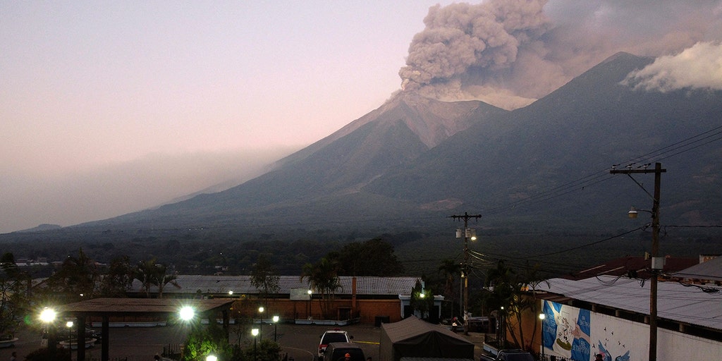
The escalation of activity at Guatemala’s Fuego volcano on August 4, 2026, represents a critical stress test for the nation’s disaster management framework. As one of Central America’s most volatile geological features, the current eruptive phase has necessitated a rapid transition by the National Coordinator for Disaster Reduction (CONRED) from monitoring to active tactical intervention, emphasizing the precarious balance between economic continuity and public safety.
Institutional Alert Escalation and Technical Parameters
The transition to an Institutional Orange Alert signifies a strategic centralization of disaster response. This administrative pivot authorizes the mobilization of national assets beyond local municipal capacities, ensuring a unified command structure. Under the direction of Executive Secretary Claudinne Ogaldes, the response has been dictated by real-time data from the Guatemalan Seismology, Vulcanology, Weather and Water Institute. Technical reports indicate lava fountains reaching heights of 650 to 1,000 feet, providing the kinetic energy necessary for the formation of lethal pyroclastic flows.
The proactive evacuation of over 650 individuals from high-risk zones, including El Porvenir and Las Lajitas, reflects a shift toward preventive risk avoidance. By prioritizing the removal of populations before the onset of catastrophic flow events, authorities mitigate the logistical burden of high-stakes search and rescue operations, which are often hindered by zero-visibility conditions and high-temperature terrain.
Infrastructure Vulnerability and Macro-Logistical Impact
The closure of National Route 14 highlights a systemic vulnerability in Guatemala’s transit network. As a primary artery connecting the southern coastal productive zones with the central highlands, its interruption induces a significant economic friction. While the closure is a tactical necessity to prevent civilian entrapment, it forces commercial traffic onto secondary routes, increasing operational costs and straining regional supply chains. This recurring failure point underscores the need for resilient infrastructure planning in high-risk volcanic corridors.
Complementary to transport restrictions, the Education Ministry’s suspension of academic activity serves a dual purpose: safeguarding the pediatric population and repurposing state facilities as coordination hubs. In Escuintla and Sacatepéquez, schools have been integrated into the emergency infrastructure, maximizing the utility of existing assets during the peak of the crisis.
Economic Risks and Humanitarian Coordination
Beyond the immediate geological threat, the eruption poses a secondary risk to the regional agrarian economy. Ash dispersion, governed by variable wind patterns, threatens the respiratory health of local populations and the viability of high-value crops. For the agricultural sector, heavy tephra fall can lead to immediate harvest loss and long-term soil contamination, potentially necessitating state-level economic intervention. Furthermore, the restriction on volcano tourism at Acatenango serves as a risk-mitigation measure, ensuring emergency resources are not diverted to non-essential rescue operations.
The humanitarian response in San Juan Alotenango and Escuintla involves the management of approximately 300 displaced persons across temporary shelters. Success in this phase depends on the efficiency of ‘last-mile’ logistics—the delivery of medical supplies and nutritional support to vulnerable demographics. This operation’s effectiveness is a key indicator of Guatemala’s institutional resilience and its ability to absorb the social shocks of recurring natural hazards.
Long-Term Strategic Implications
The 2026 eruption of Fuego reinforces the necessity of a data-driven, preemptive disaster management model. The synchronization between seismological monitoring and administrative action demonstrates an evolving institutional memory. Moving forward, the challenge for the Guatemalan state lies in reconciling the high frequency of volcanic events with the need for stable logistical corridors and sustainable economic growth in the shadow of the Volcanic Arc.

Photo by FranciscoJavierCoradoR on Pixabay.