Novel Seismic Modeling Pinpoints Rupture Zones
Researchers at the University of California, Riverside (UCR) have pioneered a groundbreaking method to precisely identify specific fault segments where critical seismic stress has accumulated. This innovation moves beyond traditional probabilistic forecasting, fundamentally shifting earthquake preparedness towards pinpointing the exact physical locations most susceptible to imminent major seismic events.
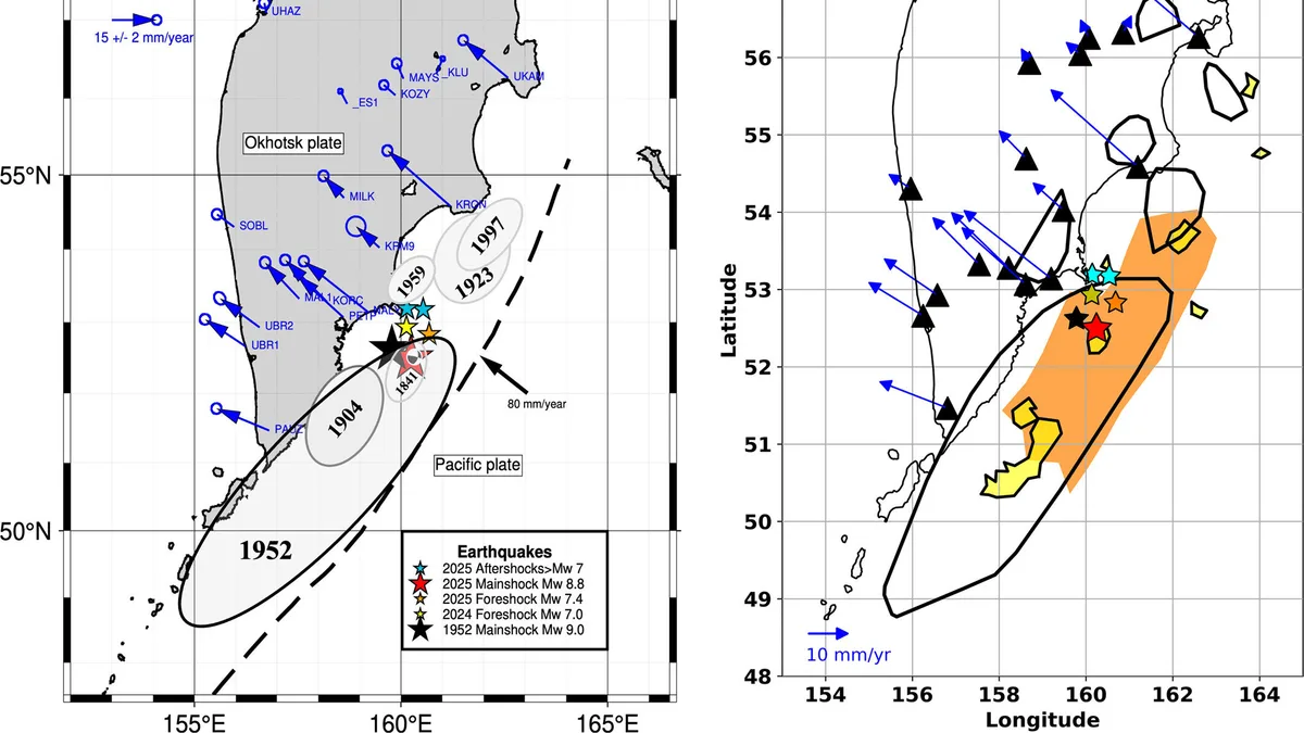
The technique, detailed in Geophysical Research Letters, leverages GPS ground deformation data to map where strain is building along subduction zones—the geological settings responsible for Earth’s most powerful earthquakes. By analyzing the subtle, slow deformation of the Earth’s surface as tectonic plates lock together, scientists can now infer which fault sections are nearing their breaking point, providing unprecedented spatial specificity.
This capability marks a critical departure from prior research, which predominantly focused on estimating broad earthquake probabilities over extended periods. The UCR model’s empirical validation—specifically, its pre-emptive identification of the exact Kamchatka subduction zone segment where a magnitude 8.8 earthquake subsequently occurred—unequivocally underscores its transformative potential for precise risk assessment and mitigation strategies.
Strategic Implications for Disaster Preparedness
The analytical precision of identifying specific rupture zones, rather than generalized probabilities, carries profound implications for disaster management agencies and urban planners. This allows for a critically targeted allocation of resources, enhancing the efficacy of seismic retrofitting initiatives, early warning system deployments, and public education campaigns in demonstrably high-risk areas.
This enhanced precision facilitates a paradigm shift from generalized seismic risk awareness to actionable, highly localized preparedness strategies. Governments and international bodies can now optimize infrastructure investment decisions and emergency response protocols, leveraging granular, data-driven insights into imminent seismic threats.
The Kamchatka validation provides a compelling, empirical basis for integrating this model into established seismic monitoring frameworks. Such integration promises a fundamental recalibration of seismic hazard maps, fostering a more dynamic and responsive approach to assessing and communicating evolving earthquake risks to vulnerable populations.
Operationalizing Geodetic Strain Measurement
The core innovation is the successful extraction of actionable seismic data from subtle, millimeter-scale ground deformations meticulously measured by GPS. UCR geophysicists Gareth Funning and Axel Periollat underscore that this accumulating strain along locked fault segments is a quantifiable physical phenomenon intrinsically preceding major ruptures.
This real-time operationalization enables continuous, high-resolution monitoring of critical fault lines, yielding a dynamic assessment of stress accumulation. The method’s strategic focus on subduction zones—regions where tectonic plates converge and one slides beneath the other—is paramount, given their inherent propensity to generate megathrust earthquakes exceeding magnitude 8.5.
Practically, this research transforms seismic hazard assessments from static models to dynamic evaluations, directly reflecting the ongoing state of stress accumulation. This crucial shift addresses the limitations of traditional assessments that often fail to capture the evolving seismic potential of a region.
Competitive Landscape and Future Research Trajectories
The UCR team’s breakthrough unequivocally positions them at the vanguard of seismic research, poised to influence future funding allocations and collaborative initiatives within the geophysics community. The demonstrable efficacy of these predictive capabilities will likely catalyze competitive pressures among research institutions and governmental agencies to rapidly refine and deploy comparable methodologies.
This advancement is also poised to spur ancillary innovation, particularly in the development of more sensitive ground deformation monitoring instrumentation and sophisticated data processing algorithms. The strategic prioritization of subduction zones for this application reflects a global imperative to address seismic risk in the most active and potentially destructive regions.
Future research trajectories will concentrate on broadening the model’s global applicability to other major subduction zones, alongside continuous refinement of strain measurement accuracy and spatial resolution. Furthermore, integrating this methodology with diverse seismic data streams promises to synergistically enhance its predictive power and operational utility.
Economic and Societal Impact of Enhanced Forecasting
The economic implications of this enhanced earthquake forecasting capability are substantial, promising significant reductions in infrastructure damage, property losses, and fostering more efficient allocation of disaster relief funding. By enabling profoundly more precise preparedness, the methodology directly mitigates the catastrophic financial externalities typically associated with major seismic events.
Societally, the capacity to anticipate the precise locales of impending major earthquakes translates directly into enhanced public safety and a substantial reduction in fatalities. This critical foresight empowers communities to implement proactive mitigation strategies, thereby cultivating greater intrinsic resilience against natural disasters.
The long-term impact foreshadows a fundamental paradigm shift in seismic risk management, transitioning from predominantly reactive responses to a proactive, predictive framework. This transformative change could fundamentally restructure insurance markets, building code regulations, and urban development paradigms across all earthquake-prone regions globally.
Challenges and Methodological Limitations
While the UCR model undeniably demonstrates significant promise, it is imperative to acknowledge its inherent limitations. Crucially, the methodology identifies where seismic stress is building, but it does not predict the exact timing of an earthquake—a critical distinction that demands unambiguous communication to the public and policymakers alike.
The model’s operational accuracy and predictive reliability are directly contingent upon the quality and spatial density of available GPS geodetic data for a specific region. Furthermore, the inherent complexities of geological structures and nuanced variations in tectonic plate kinematic behavior may present substantial challenges to the model’s universal applicability across the diverse global network of subduction zones.
Consequently, rigorous, continuous validation and methodological refinement remain essential to establish broader scientific confidence and ensure effective, widespread implementation. The global scientific community will undoubtedly monitor with keen interest as this innovative approach undergoes testing and application across diverse geological settings worldwide.