
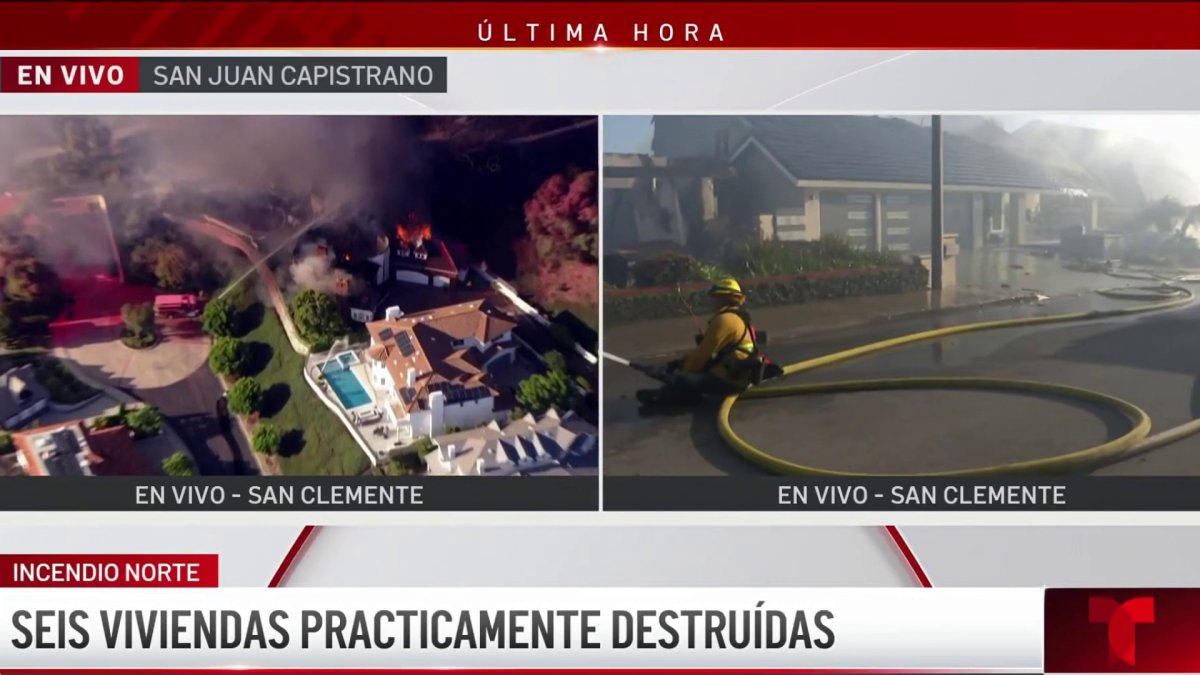
Norte Fire Ignites San Juan Capistrano Foothills
Unseasonable thermal spikes, critical relative humidity deficits, and sustained wind gusts triggered rapid wildfire propagation south of Los Angeles, breaching structural buffers in affluent foothill enclaves. According to the Orange County Fire Authority via X, the localized Norte Fire consumed approximately 188 hectares of parched brush. Driven by wind-transported embers, the blaze compromised defensive perimeters to inflict structural damage on at least four residential properties in San Juan Capistrano.
The wildland-urban interface across coastal and inland corridors, including terrain near San Clemente, exhibits extreme susceptibility to rapid fire spread. Steep topographical relief accelerates convective preheating of upslope fuels, compressing response windows between initial detection and residential impact. First responders instituted mandatory evacuation zones across exposed sectors to prevent structural entrapment as dense smoke plumes severely curtailed localized visibility.
Tactical Suppression and Evacuation Logistics
Containment efforts demanded an integrated air-ground operational profile. Incident commanders deployed ground crews alongside rotary-wing aircraft executing precision water and chemical drops to suppress forward flame fronts in inaccessible terrain. However, shifting atmospheric gusts repeatedly compromised static containment anchors by lofting embers past established defensible space.
Logistical management proved critical along municipal transit corridors. Public safety officials ordered non-essential traffic to clear regional access routes, preventing arterial gridlock that could impede the staging of heavy suppression apparatus and water tenders. The dual imperative of executing structural triage while orchestrating civilian egress underscored the operational bottlenecks inherent to high-density hillside communities.
Multi-County Dispersion and Infrastructure Fragility
Regional emergency frameworks faced simultaneous resource depletion as concurrent blazes erupted across Southern California. Active wildfire fronts manifested across Kern, Los Angeles, Orange, and San Diego counties. This four-county distribution divided tactical assets, forcing mutual-aid coordinators to prioritize life-safety operations and immediate structural protection over baseline perimeter construction.
The atmospheric and operational hazards severely disrupted regional lifeline infrastructure. Broadcast monitoring confirmed that more than 120,000 residents lost electrical service across affected municipal districts. The outages—induced by direct fire damage, elevated wind activity, and utility mitigation measures—severely degraded institutional communications, municipal telemetry, and civilian access systems across the region.
Public Health Degradation and Atmospheric Hazards
Beyond direct structural losses, regional environmental monitoring networks documented rapid air quality deterioration. High concentrations of fine particulate matter dispersed across urban valleys, posing acute respiratory risks beyond active evacuation boundaries. Inter-agency personnel maintain active containment operations as persistent wind patterns and desiccated fuel beds sustain elevated structural vulnerabilities across the Southern California basin.

Photo by TheOtherKev on Pixabay.