Himalayan Glacial Flood Devastates China-Nepal Border, Exposing Critical Trade Route Vulnerabilities
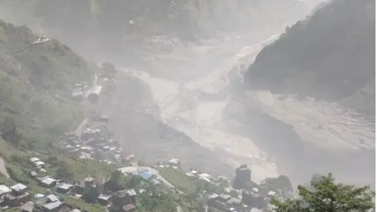
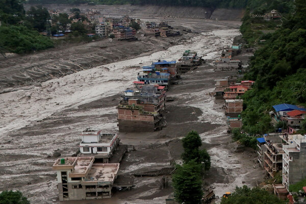
A catastrophic glacial outburst flood (GELOF) originating from high-altitude glaciers in the Himalayas has devastated communities along the Nepal-China border, resulting in substantial loss of life and hundreds of individuals missing. The torrent of mud, water, and ice, triggered by the detachment of a massive ice block from a glacier, obliterated infrastructure and overwhelmed escapees with its velocity and destructive force.
Geological assessments indicate that a colossal ice mass, estimated at 800 meters wide, fractured from a glacier at approximately 5,000 meters altitude. Its rapid descent and impact generated immense energy, pulverizing the ice into a high-energy debris flow that annihilated everything in its path.
Nepal reported 157 fatalities and over 800 missing, including approximately 400 foreign tourists. The missing Nepalese contingent comprises residents, security personnel, and government officials, underscoring the disaster’s broad impact on the local population and visitor base.
In China’s Tibet Autonomous Region, Gyirong County recorded three confirmed deaths and 558 missing persons, including 260 foreign nationals. Surveillance footage confirms the torrent engulfing parking lots and surrounding buildings near the border crossing, illustrating the immediate and overwhelming nature of the event.
The Nepal Tourism Board reported up to 391 tourists missing, with foreign nationals accounting for 291. This includes over 100 Indian pilgrims, 12 British citizens, and at least three Americans, alongside individuals from Australia, the Netherlands, Malaysia, and South Africa, highlighting the international scope of the tragedy.
Thousands in downstream riverside settlements in Nepal’s Rasuwa district, along the Trishuli and Bhote Koshi rivers, were also affected. Authorities confirmed widespread infrastructural collapse, with bridges, schools, and hydropower projects swept away, though comprehensive casualty and damage estimates are still being compiled.
Chinese state media reported “significant” casualties at the Gyirong border port, with drone footage revealing buried structures and impassable roads. President Xi Jinping has ordered prioritized search and rescue efforts and emphasized flood prevention work, signaling a high-level governmental response.
The disaster’s origin, occurring under clear skies without preceding heavy rainfall, points to a complex chain reaction of geological events. Geologists theorize that a glacial lake, possibly formed by moraine damming, experienced a sudden outburst following an ice avalanche or landslide into the river channel. This event likely created a temporary dam that subsequently breached, releasing the massive debris flow downstream.
This event is not unprecedented for the Gyirong border port, which has experienced similar cross-border mudslides in previous years. Such events, consistently traced to Nepal’s remote high-altitude regions, have previously resulted in casualties and disappearances on the Chinese side.
A critical challenge lies in China’s limited capacity to monitor upstream glacial and hydrological conditions in Nepal, contrasting with its robust domestic risk assessment systems. The inherent unpredictability of glacial lake formation and their rapid collapse provides downstream ports with an extremely limited warning window, often only about an hour, severely hindering effective evacuation.
The strategic importance of the Gyirong valley as a natural north-south corridor, historically part of the Silk Road and a crucial transit route for Sino-Nepalese trade, complicates any potential relocation efforts. The challenging Himalayan terrain makes the Gyirong Gorge one of the few viable locations for cross-border road infrastructure.
Prior to the 2015 Nepal earthquake, the Zhangmu port was the primary Sino-Nepalese land trade channel, handling over 80% of bilateral trade. Its eight-year closure until 2023 shifted trade burden to Gyirong, which now accounts for nearly 30% of bilateral trade, solidifying its role as a core freight artery.
Even with Zhangmu’s partial restoration, its location in a geologically unstable river valley, prone to landslides, means both key ports share fundamental vulnerabilities to natural disasters. The immense engineering challenges and prohibitive costs of establishing entirely new cross-border passages in the Himalayas render such alternatives impractical in the short term.
The enduring value of the Gyirong Gorge as a vital transportation artery means relocating port facilities would not mitigate the risk of downstream flooding events originating further upstream. The structural reliance on this specific geographical corridor for trade, coupled with its inherent geological instability, presents a persistent strategic dilemma for both nations.
The incident underscores the critical need for enhanced cross-border disaster monitoring and early warning systems, particularly in high-mountain glacial regions. The economic implications for trade flow and the human cost necessitate a re-evaluation of risk management strategies for critical infrastructure situated in geologically sensitive zones.
The disaster’s impact extends beyond immediate casualties, affecting supply chains and the economic viability of border trade. The recurring nature of these events highlights a systemic vulnerability requiring coordinated bilateral efforts, potentially involving advanced remote sensing technologies and collaborative data sharing on glacial lake and landslide monitoring.
Long-term strategic planning for border crossings must integrate a more robust understanding of climate change impacts on glacial melt and the increased frequency of related geological hazards. This event serves as a stark reminder of the environmental fragility of the Himalayas and its direct consequences for international commerce and human safety.